resource library
Array
Completed wetlands

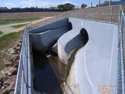
Inlet structure

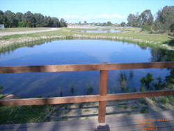
Viewing platform
Clayton South Wetlands
Kingston City Council
Namatjira Park, Clayton South | Map:
Published: 25 September 2013
Project Overview
The Clayton South Wetland is a great example of integrated water cycle management and how collaboration can achieve better outcomes and multiple benefits for the community. Melbourne Water was planning to upgrade the existing retarding basin to relieve flooding to local properties and saw an opportunity to incorporate multiple integrated water management systems.
The project included the upgrade of an existing retarding basin to provide additional flood protection to local properties, incorporate a wetland system to treat stormwater reduce pollutant loads to Port Phillip Bay, enables stormwater harvesting and reuse for Kingston City Council to water surrounding parks and gardens and improves public amenity to the local area and surrounding community.
The project involved the construction of a wetland approximately 2.3 hectares in area with pipes connecting multiple ponds. By lowering and extending the existing retarding basin, additional flood protection was achieved. In conjunction with Kingston City Council, works were undertaken along Springs Road to divert overland flows into the basin which would have previously flooded properties to the south and west.
The project transformed a previously unusable space into a more liveable and accessible place for the local community.
Melbourne Water, in collaboration with Kingston City Council determined that a better outcome for the project would be to extend the works west into the adjoining parkland. This would allow for public access to previously fenced off land. The opportunity to include a stormwater harvesting system was also realised, with funding provided from the Federal Government, Melbourne Water and Kingston City Council.
Site components
Catchment
The site is located in Clayton South, a suburb 21km south-east from Melbourne's CBD, and has a catchment area of 634 hectares. Adjoining the wetland is Namatjira Park, which includes recreational open space, sportsgrounds and is home to the "Globe to Globe" World Music festival.
Wetland
The wetland treats stormwater flows from Springs Road Drain, East Oakleigh Drain and Clayton Road Drain as well as overland flows. The wetland layout was modelled in MUSIC to determine its potential water quality results. It was determined that a flow rate of 2.6m3/s (1 in 3 month ARI storm event) discharging into the wetland would give the best detention time and water quality. A detention time of 26 hours was achieved with the final wetland configuration.
The wetland inlet structure is a complex structure configured to dissipate the velocity of water and reduce impacts to the wetland.
Stormwater flows enter sediment basins on the west and east sides of the wetland, where suspended solids are removed. The sediment basin also acts as a litter trap and collects large rubbish items from runoff before it enters the wetland ponds. A rock weir separates the sediment traps from the wetland ponds.
Three treatment ponds have been constructed forming the working wetland part of the system. Two existing habitat ponds within Namatjira Park have remained unchanged and in higher flood events receive water via a pipe from an adjacent pond. The treatment ponds consist of deep/open water, ephemeral, shallow and deep marsh zones. Multiple rock weir pits control the water levels in the treatment ponds ensuring that water remains at a suitable level preventing frequent dry outs. A controlled outlet increases detention time and also enables isolation of the wetland for maintenance purposes.
Additional flood protection
There was a known flooding issue in this area and the land is covered by a Special Building Overlay (SBO) indicating flooding from overland flows. Prior to works, 110 properties were subject to flooding in a 100 year ARI event. As part of the works the existing retarding embankment was lowered, the west levee bank removed and the basin footprint was extended into Namatjira Park. These works allowed us to capture overland flows in the newly configured retarding basin wetland system. The basin's storage volume increased to approximately 70,000 cubic metres to cater for the increased overland flows. The outlet was also altered to make the best use of the basin storage. The alterations allow higher flow at lower storage levels in the basin, but with peak outflow at top water level matched to the capacity of the downstream channel.
Stormwater harvesting
A piped connection from the westernmost pond transports the treated stormwater north to the Namatjira sporting grounds and a truck filling station point where it is harvested by Kingston City Council and used to irrigate local playing fields, gardens and important local community assets.
Drivers and Objectives
Multiple integrated objectives of the project include:
- A reduction in the use of potable water by providing an alternative water supply and allowing for stormwater reuse by the local Council
- A reduction in flood risk to properties in the local area
- Improved quality of stormwater by reducing nitrogen, sediment, phosphorous and heavy metal loads to receiving water
- Enhance visual amenity
- Provision of additional recreational opportunities for the community
Organisations
Kingston City Council (Responsible council and funding partner)
Australian Federal Government (Funding partner)
Melbourne Water (Funding partner)
Melbourne Water's Waterway Alliance (Design consultants, Project management team, Retarding basin upgrade,
Wetland construction and Plant supply and landscaping)
Open Space Infrastructure (Footbridge design and construction)
Ecosol Wastewater Filtration Systems (Litter trap)
Ecodynamics (Revegetation works)
Project Outcomes
Environmental outcomes:
- Improved water quality to receiving waters
- Reduction of approximately 1.3 tonnes per year of nitrogen, which would otherwise outlet into Mordialloc Creek and eventually to Port Phillip Bay.
- The new parklands and wetland provide habitat for a range of animals including birds, fish and frogs.
Economic outcomes:
- Provision of up to 92 million litres of stormwater harvested per year to irrigate surrounding playing fields, gardens and local community assets.
Social outcomes:
- Improved landscape amenity
- 110 properties are no longer subject to flooding and the floors of 8 houses have improved flood protection. A higher level of flood protection has been provided to 21 houses previously susceptible to low level flooding.
- Enhanced community amenity with four hectares of previously fenced off Melbourne Water owned land being opened to the public
- The construction of a footbridge, shared pathway and additional facilities provides active and passive recreation for the local community.
Lessons Learnt
Site location
The Clayton Wetlands in Namatjira Park is located approximately 1km from a landfill site. Whilst we have undertaken numerous constructed wetland/water sensitive urban design projects in Kingston City Council's municipality previously, following construction of this wetland numerous seagulls would fly between the landfill site and the wetland impacting the community's use of the site. This was most likely attributed to the sudden supply of open fresh water and Melbourne Water's bird experts advised that once the vegetation in the wetland had matured, the birds would be deterred.
This unforeseen issue was addressed swiftly in partnership with Kingston City Council. Through positive community consultation, Melbourne Water undertook a range of actions including using audio and visual deterrents to successfully reduce the seagull's numbers to the site by more than 95%.
Construction and environmental issues
Due to inclement weather during construction the site had been flooded for up to 6 months. In order to comply with EPA guidelines, a sediment control monitoring system was installed to ensure water being pumped from the site and into the waterway was not turbid and did not pose any environmental hazards. The project team used a chemical process to minimise the sediment levels in the water prior to pumping it out to the waterway.
Collaboration
This project demonstrates the importance of stakeholder collaboration. It is a great example of how the communication and collaboration between the local community, Kingston City Council and Melbourne Water resulted in multiple positive outcomes. The benefits of this project exemplify integrated water management by including stormwater treatment and harvesting, flood mitigation and improved amenity to the area.
Project Cost
The total budget (excluding ongoing maintenance costs) was $7.36M
Timeframe
2008 September
Melbourne Water's Waterways Alliance commenced concept and design work on the project
2011 January
Project construction commenced
2012 April
Project construction completed
